 Last saturday Sally and I did the Yorkshire Three Peaks walk. A great walk it was too, especially tagging along behind two members of the LDWA who specialise in 100mile non stop walks. So we moved had a brisker pace and had fewer shorter stops than we are accustomed to with The Cambridge Rambling Club 🙂 The weather was very low cloud with 12″ or so of freshish snow on all three peaks.
The gadgets I was carrying where an iPhone5 with the Moves app running & the route in the Viewranger app (although not tracking). I also had the route stored in my Garmin etrex 20 which was also storing our track as we walked it. Finally I was wearing my trusty Fitbit Ultra.
I’m pleased to say they all worked flawlessly and all their batteries stayed live for the 11 or so hours we were out. I was also carrying my Canon 550D with a 18-135mm lens.
Moves
This is a very nifty app that automatically works out if you are walking, cycling or just sat in a vehicle! It works by using the internal GPS (battery only lasts a few hours) and also the various internal motion sensors. At the end of the day it produces a summary and storyline (see left image). For this walk (and to and froing before & after) it gave a result of 58,499 steps, 25.7 miles in 10hours 29mins. You can also see the times we summited and the little stops we had.
I now use this app everyday the biggest disadvantage (apart from battery life – which to me is OKish)is that you cannot easily create a database of activity.
I kept the iPhone in an Aquapac case to stop water damage & also took a TeckNeti EP387 7000mAh external battery pack with cable. (Total weight 368gm)
Fitbit
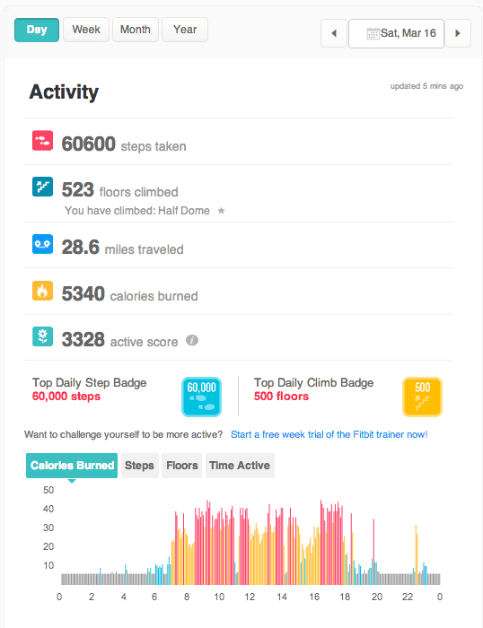
As anyone knows both Sally and I are obsessed with this amazing device.
This gave a reading of 60,600 steps, 28.6 miles. 523 floors climbed (5230 feet in normal speak) and 5340 calories burned over about 12.5 hours . So it agrees very closely to Moves.
GPS
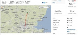
Using Ascent OSX app we get the profile and speed as: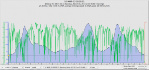
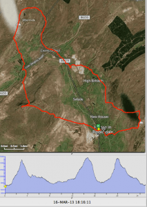
This worked out we had walked 24.8 miles in a moving time of 8hr 45min (average speed 2.8mph) with an ascent of 5,579 feet. So the other devices had a pretty good correlation. So the Fitbit really does work 🙂
All my photos of the days walk can be found here.
[pe2-image src=”http://lh5.ggpht.com/-ITldxbLXubU/UUTDgYXvFBI/AAAAAAACTLA/RkSjJEAUIyE/s144-c-o/IMG_8415.JPG” href=”https://picasaweb.google.com/111882957452855371846/20130316YorkshireThreePeaksWalk#5856020376553722898″ caption=”” type=”image” alt=”IMG_8415.JPG” ] [pe2-image src=”http://lh4.ggpht.com/-aI1a-or4HKs/UUTDkYfWVdI/AAAAAAACSxo/9ysuarfFNoQ/s144-c-o/IMG_8418.JPG” href=”https://picasaweb.google.com/111882957452855371846/20130316YorkshireThreePeaksWalk#5856020445305132498″ caption=”” type=”image” alt=”IMG_8418.JPG” ] [pe2-image src=”http://lh4.ggpht.com/-vfKtIXBHppE/UUTDwEaXKWI/AAAAAAACSyI/4lQSqiWgBBI/s144-c-o/IMG_8427.JPG” href=”https://picasaweb.google.com/111882957452855371846/20130316YorkshireThreePeaksWalk#5856020646073936226″ caption=”” type=”image” alt=”IMG_8427.JPG” ] [pe2-image src=”http://lh3.ggpht.com/-U20qzfWpX98/UUTDzrmUOaI/AAAAAAACSyQ/qNaw1-RyXNE/s144-c-o/IMG_8429.JPG” href=”https://picasaweb.google.com/111882957452855371846/20130316YorkshireThreePeaksWalk#5856020708132665762″ caption=”” type=”image” alt=”IMG_8429.JPG” ] [pe2-image src=”http://lh5.ggpht.com/-VyIHfP-zfC4/UUTEWPFYSUI/AAAAAAACSzM/UJJKkPFcMcM/s144-c-o/IMG_8444.JPG” href=”https://picasaweb.google.com/111882957452855371846/20130316YorkshireThreePeaksWalk#5856021301773748546″ caption=”” type=”image” alt=”IMG_8444.JPG” ] [pe2-image src=”http://lh4.ggpht.com/-wNwghhkLHIE/UUTFGR2GqhI/AAAAAAACS4s/3RJllI9OqCU/s144-c-o/IMG_8466.JPG” href=”https://picasaweb.google.com/111882957452855371846/20130316YorkshireThreePeaksWalk#5856022127148706322″ caption=”” type=”image” alt=”IMG_8466.JPG” ] [pe2-image src=”http://lh5.ggpht.com/-oEUgnRkl8pM/UUTFJVg3OtI/AAAAAAACS0w/2gi-iBV4EqE/s144-c-o/IMG_8469.JPG” href=”https://picasaweb.google.com/111882957452855371846/20130316YorkshireThreePeaksWalk#5856022179672963794″ caption=”” type=”image” alt=”IMG_8469.JPG” ] [pe2-image src=”http://lh3.ggpht.com/-bE_pthyfLb4/UUTFeHvqewI/AAAAAAACS1c/0Ip8AJO9vZw/s144-c-o/IMG_8480.JPG” href=”https://picasaweb.google.com/111882957452855371846/20130316YorkshireThreePeaksWalk#5856022536754199298″ caption=”” type=”image” alt=”IMG_8480.JPG” ] [pe2-image src=”http://lh5.ggpht.com/–Ig4y1i2L-Q/UUTF_4BlvzI/AAAAAAACSuY/IDRkueWueEo/s144-c-o/IMG_8494.JPG” href=”https://picasaweb.google.com/111882957452855371846/20130316YorkshireThreePeaksWalk#5856023116649971506″ caption=”” type=”image” alt=”IMG_8494.JPG” ] [pe2-image src=”http://lh5.ggpht.com/-ZwdvBagJzcY/UUTGucJrDUI/AAAAAAACTGk/HF40lfTRl7M/s144-c-o/IMG_8519.JPG” href=”https://picasaweb.google.com/111882957452855371846/20130316YorkshireThreePeaksWalk#5856023916621532482″ caption=”” type=”image” alt=”IMG_8519.JPG” ] [pe2-image src=”http://lh4.ggpht.com/-mUqnVn3_KcI/UUTHGDoTM0I/AAAAAAACSwo/ZMFpIp2y4to/s144-c-o/IMG_8531.JPG” href=”https://picasaweb.google.com/111882957452855371846/20130316YorkshireThreePeaksWalk#5856024322355966786″ caption=”” type=”image” alt=”IMG_8531.JPG” ] [pe2-image src=”http://lh5.ggpht.com/-MbqhPd9G6lk/UUTHJeYzCgI/AAAAAAACS5M/UaQY4OXFizQ/s144-c-o/IMG_8533.JPG” href=”https://picasaweb.google.com/111882957452855371846/20130316YorkshireThreePeaksWalk#5856024381078309378″ caption=”” type=”image” alt=”IMG_8533.JPG” ] [pe2-image src=”http://lh5.ggpht.com/-wqm5H-dhe9g/UUTHKUXvPmI/AAAAAAACSw0/mMLp0k7jnQ4/s144-c-o/IMG_8534.JPG” href=”https://picasaweb.google.com/111882957452855371846/20130316YorkshireThreePeaksWalk#5856024395569380962″ caption=”” type=”image” alt=”IMG_8534.JPG” ] [pe2-image src=”http://lh3.ggpht.com/-JSSMwjHa8LI/UUTHWgrIzQI/AAAAAAACSxQ/BBw-qpjJXMo/s144-c-o/IMG_8544.JPG” href=”https://picasaweb.google.com/111882957452855371846/20130316YorkshireThreePeaksWalk#5856024605030403330″ caption=”” type=”image” alt=”IMG_8544.JPG” ] [pe2-image src=”http://lh4.ggpht.com/-DLzmt0xEgMY/UUTHZjoZcSI/AAAAAAACS14/tp0-eIDIl1k/s144-c-o/IMG_8546.JPG” href=”https://picasaweb.google.com/111882957452855371846/20130316YorkshireThreePeaksWalk#5856024657363824930″ caption=”” type=”image” alt=”IMG_8546.JPG” ]
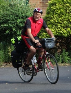 Today marks my first cycling day in this years marathon ride which, hopefully, will take me to Les Gets to visit my apartment and maybe meet Euan for a walk or two. I hope to cycle over to Zurich to see my neühew then onto the start of The Danube River at Donoueschlingen, cycling down it’s full length of 2886 km (1,800 miles) to The Black Sea. Not sure what to do then but maybe go down to Istanbul.