Today I ventured out of Quito with Margaret (who I met in Samara in my first language class) to find The Equator.
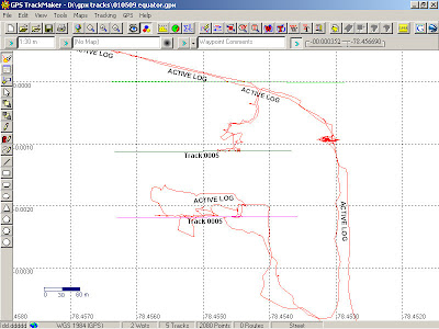
Armed with my Garmin GPS we took the public transport buses, 50 cents for a 30km journey, to Mitad del Mundo where the Equator was determined in 1736 and the nearby Museo Inti-Nan which claims to be on the actual equator as determined by someones GPS. However , my Garmin told a different story! Here are the traces for the day:-
The lower trace is Mitad del Mundo, the centre one is museo inti-Nan and the one at zero is my Garmin…
Wikipedia has more on the subject here
Before we did the Equator we visited the rim of the old Pululahua crater which was interesting to see a community sitting on top of a volcano, like Yellowstone National Park in the USA!
The photographs of the day are on Picasa.
B
By the way the trick of showing the water going down the plughole in opposite directions in each hemisphere is revealed in some detail here


Good post Geoff….I lived near the equator for a few years..in Singapore!
some great photos…. and i bet it was great trying out all the equater experiments 🙂
some great photos…. and i bet it was great trying out all the equater experiments 🙂